Footscray History, Photos, Maps and Estates Unrestored
These raw historic pieces are options worthy for digital restoration, printing, and framing. If there is something of interest here for your home, you can order it via the Custom Order Product in our store. Just copy the title below the item of choice. The prices show include the restoration fee.
Contact us via our form to discuss further options.

Aerial view of Footscray. Looking along Barkly Street; Footscray Railway Station in right background, St. Monica's Catholic Church just visible in upper left background. 1954

Barkly Street Footscray 1920-40

Footscray Park with huge crowds watching the Melbourne Cup


Plan of Footscray, being subdivision of portion 8, section 15, Parish of Cut Paw Paw 1850s

Manchester Estate Footscray 1800?s Gerald Street, Swallow Street, Derham Street, Edward Street, Verney Street, Geelong Road, Lightfoot Street, Isabel Street, Somerville Road, Loscombe Street, Eleanor Street, Lizzie Street, Frances Street, Anne Street, Holmwood Road

Yarra Road -- Munro's Road -- Station Road -- Commercial Road -- Heales Road -- Latrobe Road -- Bay View Road 1871


Robbs Road Footscray Board of Works 1937

Plan of subdivision for workman's homes, City of Footscray, Parish of cut Paw Paw, County of Bourke. 1914

Map of part of Footscray - Department of Crown Lands and Survey 1920s

Footscray Oval, home of Footscray Football Club ca 1925-35


This is a breakout detail map from one of the master Cut Paw Paw maps of the Hansen area in 1885 – pre-Hansen Street realisation

This is a breakout detail map from one of the master Cut Paw Paw maps of the Hansen area in 1885 – pre-Hansen Street realisation - Mockup

1925-40 Footscray West at intersection of Geelong, Robbs and Graingers Roads

1940s Hansen Street, Geelong Road & Robbs Road Footscray

Geelong Road, West Footscray, including premises of Col Shea, butcher at no. 273 Geelong Road

Geelong and Sunshine Roads, West Footscray with Mitchell & Co and Implements near Footscray Football Ground (Whitten) 1949

Footscray, showing George Kinnears rope factory on the corner of Ballarat Road Farnsworth Avenue Droop 1925-40
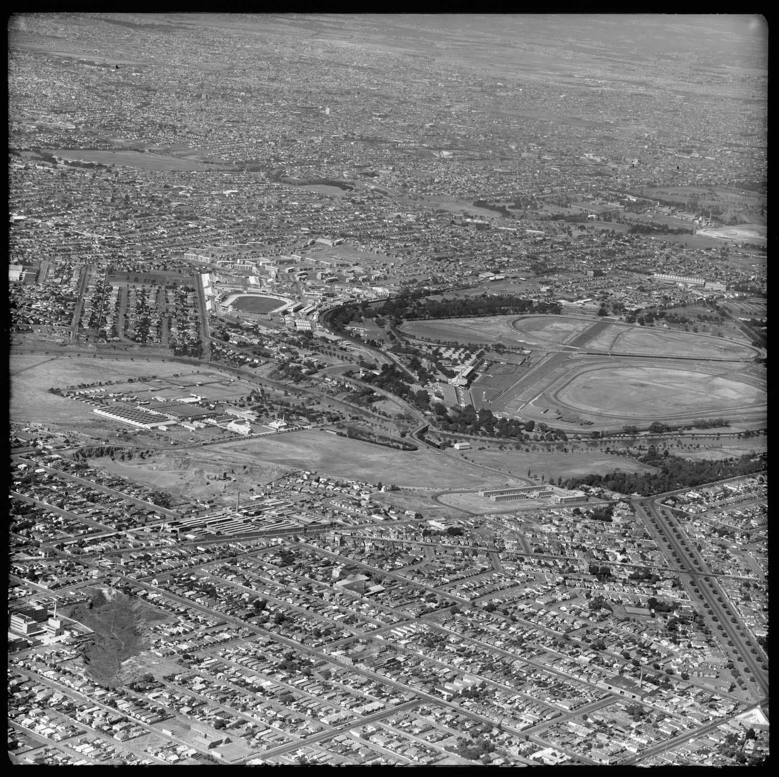
1953 - Aerial view of Footscray, Flemington and Ascot Vale, looking east. Footscray Hospital bottom left next to the old quarry.

Aerial - Footscray area showing Explosives Factory, Maribyrnong, in centre of image, Maribyrnong River on right, with the White Lady Tea Gardens upper right above jetty 1926

FOOTSCRAY and COOTE 1920-40

1926-27 Footscray. Looking south from Bunbury and Napier Streets toward Yarraville Gardens in the distance with mini trees. Includes Moreland and Whitehall Streets. You can see Bunbury St dug open at the very bottom.

South Kensington to West Footscray - Bunbury Street tunnel 1927 1

South Kensington to West Footscray - Bunbury Street tunnel 1927 2

South Kensington to West Footscray - Bunbury Street tunnel 1927 3


South Kensington to West Footscray - Bunbury Street tunnel 1927 4

South Kensington to West Footscray - Bunbury Street tunnel 1927 4

South Kensington to West Footscray - Bunbury Street tunnel 1927 5

South Kensington to West Footscray - Bunbury Street tunnel 1927 5

South Kensington to West Footscray - Bunbury Street tunnel 1927 7

South Kensington to West Footscray - Bunbury Street tunnel 1927 8

South Kensington to West Footscray - Bunbury Street tunnel 1927 9

South Kensington to West Footscray - Bunbury Street tunnel 1927 10

Looking down Bunbury St. from Footscray ramp 1927

Pouring concrete at the back of retaining wall at Bunbury St 1927

Exterior view of Kinnear's Rope Works, Ballarat Road, Footscray 1944

Footscray Station 1905

Footscray Motors, Hugh Williams Pty Ltd, 71 Hopkins Street, Footscray 1930s

Footscray Town Hall 1930s

Footscray, section 16, Parish of Cut Paw Paw Auction 1857

Essex St - Plan of 540 quarter acre allotments, near the Township of Footscray 1857

1899 Plan of land for sale Well-selected properties in Collingwood, Northcote, Footscray, Pentridge, and Keilor

Bottomleys Paddock Footscray, section 16 Parish of Cut Paw Paw 1855

Droop St The Tiernan Estate, Crown allotments 19, 20 and 22 1900

The two triangle of Droop St - Geelond Road Footscray, 13th October 1864

Footscray, Moore, Byron, Shelley, Hopkins Sts 1872

Mooreland, Ryan, Whitehall Sts The finest property in all Footscray 1859
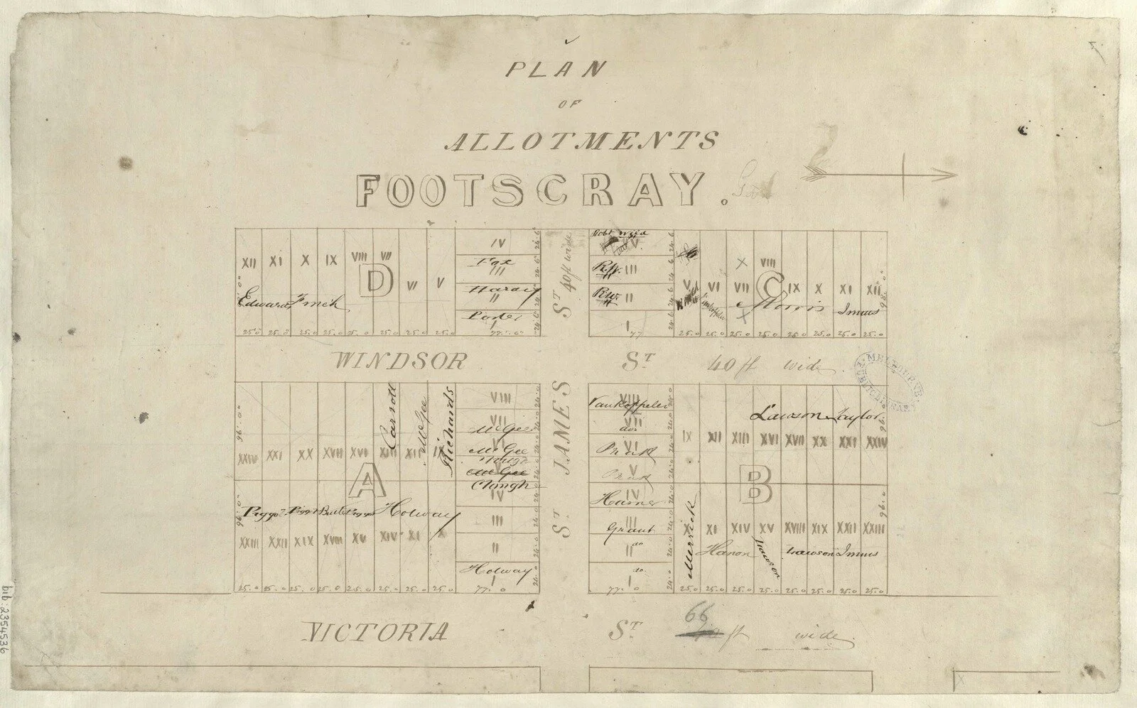
Windsor James Victoria Street Footscray 1850s

Plan of Hobbs' Paddock Footscray. Allotment A, of section 14, Yarra Street, Dane Street, Earl Street, Pole Street, Railway Street, Store Street 1850

Footscray - Charles, Albert, Austin, Walter, Buckley, Victoria 1850-1880

Footscray - Seddon. Charles, Albert, Austin, Walter, Buckley, Victoria 1853

The Township of Footscray, Parish of Cut Paw Paw 1857 Hyde Street, Lyons Street, Whitehall Street, Morland Street, Wingfield Street, Napier Street, Sunbury Street

Footscray Post Office 1899
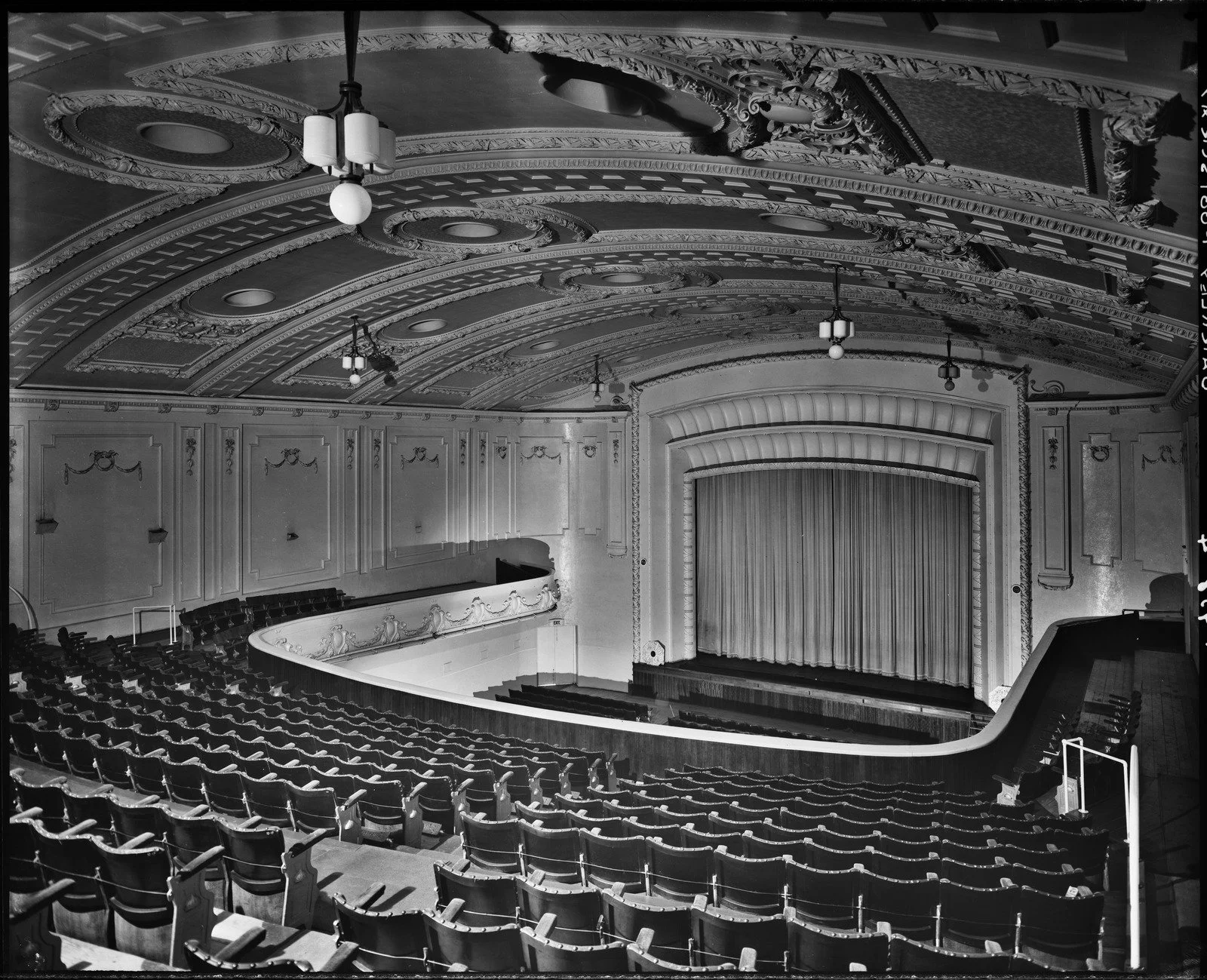
Interior view of Barkly Theatre, 281 Barkly Street, Footscray 1940s

Footscray Railway Station employees 1926

Creamoata factory and Bishop's Combined Seed Grading and Dusting Machines building, Sunshine Road, West Footscray 1940s

Barkly Street, Footscray 1909 Postcard